
We’ve — finally! — collaborated with the fabulous Jen Bekman’s 20×200 on a print edition of a Stamen project, Prettymaps. 20×200 makes it possible for people to buy art at whatever level they’re comfortable, from $20 to $200, and the project has put art into the hands of lots of people who wouldn’t otherwise afford it, so good on them. Jen’s written up a pretty comprehensive blog post about the project, which I’ve shamelessly copied and pasted below.
I don’t have much else to add to what Jen’s written (she’s good) other than to say that any profits we receive on the project will be donated to theHumanitarian Open Street Map Team (Aaron’s idea), in recognition of the incredible work that team does to increase citizen access to data under sometimes difficult and dangerous conditions. Oh, and also to mention that Aaron signed his name 2127 times during the making of the project, and is on a well-deserved break as a result.
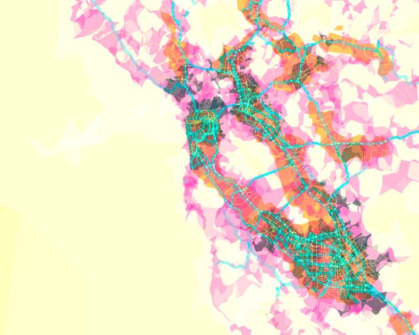
prettymaps (sfba) by Aaron Straup Cope
Greetings from the West, collector friends! I write to you from my second city of San Francisco, which is fitting, considering it’s both the subject of today’s edition and the happy home of its makers. As long-time subscribers know, I spend a lot of time in the Bay Area and like it that way. Living here in the 90s was formative and it’s a place that continues to inspire the tech-centric entrepreneurial side of my Jekyl & Hyde / art & tech existence. Its community of creative technologists is dismantling the wall that exists between the two, as exemplified by today’s edition, prettymaps (sfba) by Aaron Straup Cope, produced in association with Stamen, an innovative studio founded by my long-time friend (and high school classmate!) Eric Rodenbeck.
We live in a time of big (huge!) data; Stamen was among the first to recognize that all this data can be beautiful and has made a name for itself by creating stunning, often interactive, visualizations of complex datasets. Their vision was endorsed by MoMA, when Paola Antonelli included Cabspotting in their history-making Design and the Elastic Mind exhibition. As Stamen was making a name for itself in the art and tech worlds, Aaron was making some ground-breaking of his own in the engineering group at Flickr, doing amazing things with photographs and mapping data. prettymaps is the product of the convergence of not just data, but talent and what a beautiful result! With beauty comes understanding — by making data beautiful, a path is cleared into an overwhelming and often intimidating barrage of information.
This edition is particularly exciting to me because it’s a MAP and maps are something that we’re really nuts about.* What exactly areprettymaps made of? They’re made of you! When you visit prettymaps.stamen.com, what you’re seeing is an amalgamation of community-generated data. It draws from things like Flickr Shapefiles, which are Flickr’s geo-tagged photos plotted out (there are lots and lots, like, tens of millions) and road, highway and path data collected by Open Street Map.
Today’s SF map is the first in a series from Aaron. You can count on seeing prints documenting our favorite cities released in the coming weeks, and that’s just the start of it! Our editions past also evidence our affections for making sense, and sometimes nonsense, of information: Stefanie Posavec’s dismantling of Walter Benjamin, Chad Hagen’s Nonsensical Infographics and even Wendy MacNaughton’s attempt to turn emotions into parse-able pieces. We’re information junkies when it comes down to it, and our aesthetic addiction is well-evidenced in the editions we’re queuing up for the balance of the year.
*We’ve been drooling over The Map as Art at 20×200 HQ. The book features the work of more than a couple artists we’re crazy about, including a not-to-be-named (yet!) legendary artist/designer we’re working with to bring editions to you.
By Jen Bekman